Skip to content
Accessibility
  • Text Size:
  • Normal
  • Large
  • Larger
  • Screen Colours:
  • Normal
  • Black & Yellow
Dedham Parish Council
  • HOME
  • PARISH COUNCIL
    Parish Councillors Current Minutes Current Agendas Annual Audits Finance Documents Policy Documents Annual Reports Working Groups Terms of reference Statutory Documents Planning and Planning Applications Environmental Parish Plan Grants Terms and Conditions Accessibility Statement Business Focus
  • CONTACT US
  • TRAFFIC ISSUES
    Automatic Traffic Counts Essex Highways - Dedham Parish Traffic Management Review 2023
  • SUSTAINABLILITY
    Towards a Greener Dedham Water Quality Norwich Tilbury
  • DEDHAM
    Village Life Dedham Parish Magazine Walks Maps of Dedham Historical Dedham Dedham - Massachusetts Photo Gallery
  • LINKS
    Village Life Village Sports Medical Services Local Services Local News Services and Utilities Retail Transport Dedham Vale Inns, Restaurants and Cafes Accommodation
  • ARCHIVE
    DPC Minutes Archive Parish Council Document Archive Parish Magazine Archive AONB Documents Footpaths & Walks
  • TRAVEL
    Future Roadworks Map National Highways

Maps of Dedham

DEDHAM » Maps of Dedham

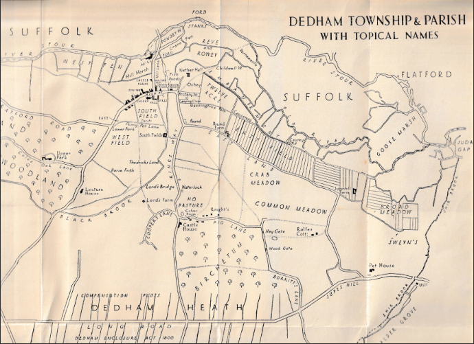
This section is devoted to maps of Dedham including Ordance Survey maps recently scanned by the National Library of Scotland.  The first map is a map of Dedham Township and Parish with Topical names, Feudal and Medieval.  The map shows the compensation plots and the Dedham enslosures on Long Road West.  This map was included in the book by Gerald Rendall, Dedham in History - Feudal, Industrial, Ecclesiastical, published in 1937. 


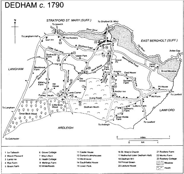
The Victoria County History of Dedham includes a map from around 1790, shown below.

Map images from the National Library of Scotland. 

In the NLS 'Map images' resource you can access and view all the maps that NLS have scanned as high-resolution, colour, zoomable images. The maps date between 1560 and 1964 and relate primarily to Scotland but also have maps of areas beyond Scotland, including maps of England and Great Britain, Ireland, Belgium, and Jamaica.


1875 OS 6 inch map of Dedham
 
1896 OS 1 inch map of Dedham
 
1902 OS 25 inch map of Dedham
 
1921 OS 6 inch map of Dedham
 
1955 OS 1:25,000 map of Dedham
 
Current OS map of Dedham
 

Last updated - 14/02/2025

 WAVE check. No errors.

Parish Council News
    ROADWORKS IN MAY/JUNE/JULY COLCHESTER CITY COUNCIL - CLEAR RECYCLING BAGS. LOCAL ROADWORKS IN THE AREA OVER THE NEXT FEW WEEKS. COLCHESTER CITY COUNCIL LOCAL PLAN PREFERRED OPTIONS

Copyright © 2025, Dedham Parish Council

Accessibility Terms & Conditions Feedback Dedham Parish Church onesuffolk

This site uses cookies to store information on your computer.

Do you want to allow cookies on this site?

Allow all cookies on this site

Alternatively, you may customise your cookie preferences bellow.
Some parts of this site may be disabled if cookies are blocked.

Allow only local cookies on this site
Block all cookies on this site

'Local cookies' are cookies generated by our site to enable some functionality. Other cookies are those used by external sources such as Google, Facebook or Youtube to enable their features on our website.

For more information about cookies click here.